Interactive Election Maps
I have added a number of interactive election maps for the following:- UK Parliament
- Scottish Parliament
- Welsh Assembly.
Using the Election Maps
By default the maps are blank. You can import data from the polls pages, the results pages and the swingometers.Colours

To colour the constituencies, simply select a colour and click the constituency which you want to change colour.
Buttons
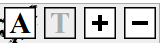
The A button turns on constituency hyperlinks.
The T button turns on constituency names, without hyperlinks.
The + button zooms in.
The - button zooms out.
Download Options
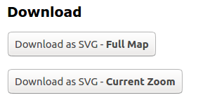
You can download the full map or the current zoom with the above options.
Posted 16 Aug 2020, 14:00